By May 14…
By May14 we are approaching the El Malpais National Monument. We’ve been here before, but this time we want to dive a little deeper into the landscape and the culture.
We spent two nights at a little Department Of the Interior campground called Joe Skeen Campground. It’s nice to stop and relax after a day or two of driving.
Then it poured rain on the day we had planned to hike out on the lava beds. We skipped the hikes, but really enjoyed the Visitor Center located just outside of Grants, New Mexico. It’s an eye-catching new building evocative of the Southwest with a large museum that focuses on the indigenous culture of the area and how it has changed over time. It is located at the North end of the lava beds.
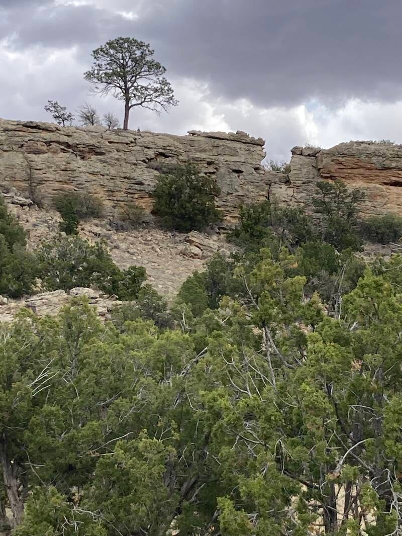
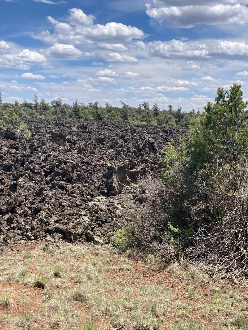
We took the scenic route South through the El Malpais Monument and marveled at the volcanic landscape. It was not the smooth, shiny black flow areas we had imagined. Instead it was a chaotic dull black jumble of pumice-looking sharp rocks sticking up and pointing every-which-way and impossible to traverse. How did anyone manage to settle and survive on this “land”?
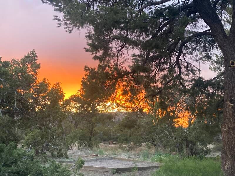
The road through El Malpais takes you to El Morro National Monument. This small park celebrates a tall sandstone bluff that contains petroglyphs and graffiti from long ago travelers through the area. They have a small, free campground with seven sites. For a free place, it was amazing— had trash service, water spigots, and a toilet. Sites were way too close together, though. You could sit at our picnic table and have a clear view of three other tables. And if I sat outside in my chair, I could hear entire conversations from the camp next door. A thunderstorm passed through on our first day at El Morro. By end of day the rain was over, but there were massive banks of clouds just above the horizon. The sunset that night was spectacular.
When we left El Morro, we took a road called Backcountry Byway (county road C42). Also called Chain of Craters, this road takes you by six inactive volcanic vents. Sounded like the perfect 40-mile-long scenic drive to us. Just after we turned onto C42, a BIG sign noted that the road was county maintained, but was IMPASSABLE when wet. Road didn’t look too wet, but it had rained in the area more than once in the past few days. We said, “Well, if it gets too messy we can turn around.” Famous last words. The road was fairly rutted from previous people driving on it wet, so that took some skill just to get around the ruts and the areas where people had obviously been stuck in the mud and made it all worse as they struggled to get out. We pulled over at one point and had a picnic lunch. We said “This isn’t so bad. We got this.” Then the road began to have dips in it where so much water had collected that people had driven around the dip, up above the side of the road. It reminded me a lot of the road out to Buffalo Ranch in Nevada and how we would have to lock into 4 wheel drive, gun the Jeep, and drive onto the desert above the shoulder in order to pass the muddy mess of the road. Remember those exciting drives home from school, kids? On Road C42 we drove around numerous big puddles, gunning Morrison as we came back down onto the road from the bypass and sliding a bit when we hit the last bit of mud in the puddle. We said “Wow, good thing people have made these pathways around the dips. This isn’t so bad. We got this.” Then we reached a puddle that covered the entire roadway and had no way to drive around it. Dave got out to take a look. Water was so muddy you couldn’t see how deep it was or if there were holes or rocks lurking there. I thought “Ah well, that’s it, we’ll have to turn around.” Dave came back to the van. “I can see where somebody crossed with duallies. I’m gonna follow their tracks.” In his mind, this meant that a heavy vehicle had made it through, so Morrison could too. I was unsure about this. He backed up a little, then headed through the water, giving Morrison the gas and we rolled up our windows quick so the splash didn’t come inside. I held my breath. If we got stuck, Morrison would be too heavy for the two of us to push free. How long might it be before someone came along who could help? No cell signal meant no tow truck. It was a moment that lasted forever. But Morrison (and his new 50% off-road tires) did his job and we made it through the puddle, just fish-tailing a little at the end. There were many more puddles to come and we navigated them all. Eventually the terrain changed and the road was drier. We said “Ok, we got this now. We’re past the muddy part.” We tooled along for a while at about 25 miles per hour. We climbed out of the boggy region and up onto a grassy plateau. We passed some of the volcanic vents. Unfortunately the road now had expanses of exposed volcanic rock, worn smooth over time, mostly on the downhill side of small hills. For that, we had to CRAWL at a snail’s pace to protect Morrison’s new tires. This scenic 40 mile byway had taken us maybe four hours to travel. It was worth it, though. The challenge of the road was reminiscent of driving up Mt. Moses at the Nevada ranch to move sheep camps and deliver supplies. We had a good time, but Dave said that if he had started that road from the other end and faced those exposed rock sections going uphill, he would have turned around early on and never taken that road. Think of how much we would have missed.